Reduce Tedious Foundation Analysis Without Sacrificing Engineering Standards
Generate forensic topo models, automate severity calculations, and produce defensible deliverables faster — with engineering-grade precision and transparent analysis workflows.
Faster Turnaround ● Defensible Deliverables ● Automated Severity Calculations
Reduce Tedious Foundation
Analysis Without Sacrificing
Engineering Standards
Generate forensic topo models, automate
severity calculations, and produce defensible
deliverables faster — with engineering-grade
precision and transparent analysis workflows.
Faster Turnaround ● Defensible Deliverables ● Automated Severity Calculations
AUTOMATION WITH
TRANSPARENCY & PRECISION
Stop Spending Hours on Repetitive Analysis Work
Manual topo interpretation, elevation calculations, severity analysis, and reporting workflows
slow down turnaround time and create unnecessary bottlenecks.
SPATIALVISION™ helps engineers standardize forensic foundation analysis with
automated workflows, transparent calculations, and engineering-grade visualization tools.
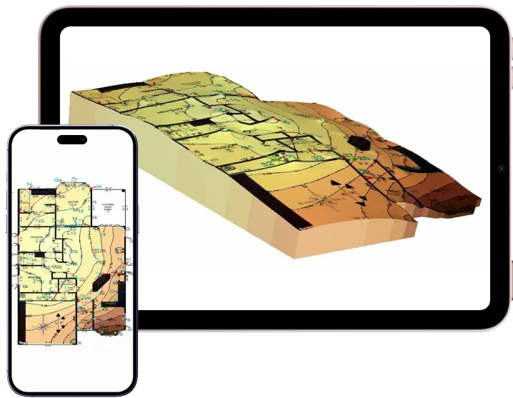
Cloud-Based 〉Instant Access 〉Direct from Mobile or Tablet
Cloud Based 〉Instant Access 〉Direct from Mobile or Tablet

NO
INSTALLATIONS

ENGINEERING-GRADE
MODELLING

COLLABORATE
& SHARE
AUTOMATION WITH
TRANSPARENCY & PRECISION
SEE IT. TRUST IT. DONE.
Cloud Based 〉Instant Access 〉Direct from Mobile or Tablet
Cloud Based 〉Instant Access 〉Direct from Mobile or Tablet
NO
INSTALLATIONS
POWERFUL
MODELLING
COLLABORATE
& SHARE
AUTOMATION WITH
TRANSPARENCY & PRECISION
Stop Spending Hours on Repetitive Analysis Work
Manual topo interpretation, elevation calculations, severity analysis, and reporting workflows slow down turnaround time and create unnecessary bottlenecks.
SPATIALVISION™
helps engineers standardize
forensic foundation analysis with automated workflows, transparent calculations, and engineering-grade visualization tools.
Cloud-Based 〉Instant Access 〉
Direct from Mobile or Tablet
NO INSTALLATIONS
ENGINEERING-GRADE MODELLING
COLLABORATE & SHARE
AUTOMATE SEVERITY CALCULATIONS
Arrive at standard industry allowables without repetitive manual calculations and
spreadsheet work.
GENERATE DEFENSIBLE DELIVERABLES
Produce clear topo models, placement visuals, and geo-referenced outputs that support
transparent engineering analysis.
TRACK FOUNDATION MOVEMENT OVER TIME
Compare historical surveys and elevation data to identify movement patterns and monitor structural changes across projects.
AUTOMATE SEVERITY
CALCULATIONS
Arrive at standard industry allowables without repetitive manual calculations and
spreadsheet work.
GENERATE DEFENSIBLE
DELIVERABLES
Produce clear topo models, placement visuals, and geo-referenced outputs that support
transparent engineering analysis.
TRACK FOUNDATION MOVEMENT
OVER TIME
Compare historical surveys and elevation data to identify movement patterns and monitor structural changes across projects.
STANDARDIZE YOUR
FORENSIC ANALYSIS WORKFLOW
CAPTURE ELEVATION DATA
Import field measurements and generate
a precise foundation topo model
automatically.
ANALYZE SEVERITY & MOVEMENT
Apply automated calculations, compare historical surveys, and evaluate differential movement using industry-standard analysis methods.
DELIVER CLEAR ENGINEERING OUTPUTS
Generate geo-referenced visuals, transparent calculations, and client-ready deliverables without rebuilding analysis manually.
AUTOMATE THOUSANDS OF
SEVERITY CALCULATIONS IN SECONDS
Maintain engineering-grade accuracy with verifiable processes
that support your standards and professional responsibility.
____________________________________
Generate 3D topo models in as little as 45 seconds
without sacrificing analytical rigor.
____________________________________
Calculate industry-standard allowables without repetitive
manual calculations or spreadsheet work.
STANDARDIZE YOUR
FORENSIC ANALYSIS WORKFLOW
CAPTURE ELEVATION DATA
Import field measurements and
generate a precise foundation
topo model automatically.
ANALYZE SEVERITY & MOVEMENT
Apply automated calculations,
compare historical surveys, and evaluate differential movement using industry-standard analysis methods.
DELIVER CLEAR ENGINEERING OUTPUTS
Generate geo-referenced visuals, transparent calculations, and
client-ready deliverables without rebuilding analysis manually.
AUTOMATE THOUSANDS OF
SEVERITY CALCULATIONS
IN SECONDS
Maintain engineering-grade accuracy with verifiable processes that support your standards and professional responsibility.
____________________________________
Generate 3D topo models in as little as 45 seconds without sacrificing analytical rigor.
____________________________________
Calculate industry-standard allowables without repetitive manual calculations or spreadsheet work.
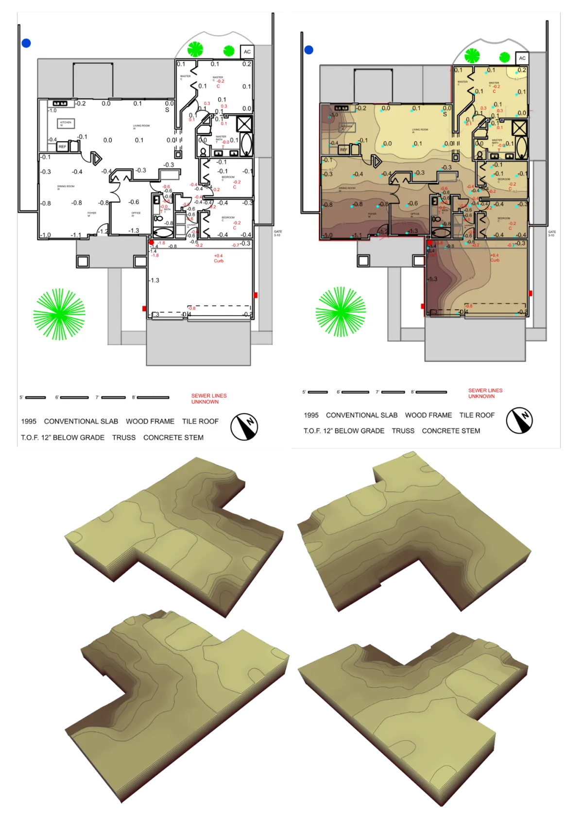
Automatic Calculations of Tilt & Deflection
Streamlined Data Collection & Analysis
Color-Coded Visuals Make Complex Findings Easier to Communicate
Cloud-Based Access Across Devices
Track Foundation Changes Over Time for Consistent Data Comparison
Industry-Expert Assistance & Support

Automatic Calculations of Tilt & Deflection
Streamlined Data Collection & Analysis
Color-Coded Visuals Make Complex Findings Easier to Communicate
Cloud-Based Access Across Devices
Track Foundation Changes Over Time for Consistent Data Comparison
Industry-Expert Assistance & Support
ENGINEERING-GRADE ANALYSIS
YOU CAN DEFEND
SpatialVision™ was built to support transparent
forensic workflows — not black-box outputs.
Every model, calculation, and visualization
is designed to help engineers:
Maintain consistent analysis standards
Reduce manual interpretation errors
Produce verifiable deliverables
Improve documentation clarity
Protect professional credibility
Increase Throughput Without
Increasing Analytical Friction
Reduce time spent on repetitive processing and
reporting so your team can:
Complete more projects
Standardize deliverables across engineers
Shorten turnaround times
Onboard junior engineers faster
Focus more time on engineering judgment
instead of repetitive calculations
ENGINEERING-GRADE ANALYSIS YOU CAN DEFEND
SpatialVision™ was built to support transparent forensic workflows — not black-box outputs.
Every model, calculation, and visualization is designed to
help engineers:
Maintain consistent analysis standards
Reduce manual interpretation errors
Produce verifiable deliverables
Improve documentation clarity
Protect professional credibility
Increase Throughput Without Increasing Analytical Friction
Reduce time spent on repetitive processing and reporting so your team can:
Complete more projects
Standardize deliverables
across engineers
Shorten turnaround times
Onboard junior engineers
faster
Focus more time on engineering judgment instead of repetitive calculations
SEE how SPATIALVISION™ fits into your engineering workflow
Generate topo models, automate analysis workflows, and produce
more defensible forensic deliverables with less manual effort.
SEE how SPATIALVISION™ fits into your engineering workflow
Generate topo models, automate analysis workflows, and produce
more defensible forensic deliverables with less
manual effort.
SIMPLE, STRAIGHTFORWARD PRICING
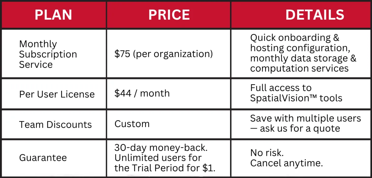
SAMPLE PRICING BREAKDOWN:
1 organization with 1 user
Month 1: $1 (30-Day Trial)
Month 2 and onwards: $75 + 44 = $119
1 organization with 2 users
Month 1: $1 (30-Day Trial)
Month 2 and onwards: $75 + $44 + $44 = $163
$1 is your credit card provider's verification requirement. The 30-day trial is absolutely free.
⚙️ Need multi-seat access or enterprise support? Contact us for custom pricing. ⚙️
SPATIALVISION™
3D Topo Visualization Software
(Demo snippets 0:58 - 6:25)

SIMPLE, TRANSPARENT PRICING
No hidden fees.
Just straightforward pricing.
SAMPLE PRICING BREAKDOWN
1 organization with 1 user
Month 1: $1 (30-Day Trial)
Month 2 & onwards: $75 + $44 = $119
1 organization with 2 users
Month 1: $1 (30-Day Trial)
Month 2 & onwards: $75 + $44 + $44 = $163
$1 is your credit card provider's verification requirement. The 30-day trial is absolutely free.
⚙️ Need multi-seat access or
enterprise support? Contact us
for custom pricing. ⚙️
SPATIALVISION™
3D TOPO VISUALIZATION SOFTWARE
(Demo snippets 0:58 - 6:25)
A subsidiary of
Accuracy ● Precision ● Reliability ● Integrity
Accuracy ● Precision
Reliability ● Integrity
Helping You Achieve More
with Less Tedious Work.
Helping You Achieve More
with Less Tedious Work.
Copyright SPATIALVISION™ A Subsidiary of Transparent Engineered Solutions™ (TES™)
Copyright SPATIALVISION™ A Subsidiary of
Transparent Engineered Solutions (TES)